Slatuinenweg in De Baarsjes remains lower than the city that grew around it
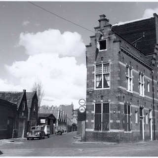
The Slatuinenweg in Amsterdam is a historic road that originated as an eighteenth-century path for market gardens and later became a popular rural destination. Following the annexation of the municipality of Sloten by Amsterdam in 1921, urban expansion left the low-lying path physically separated from the newer surrounding infrastructure.
The Slatuinenweg in Amsterdam is a historic path that remains noticeably lower than the modern urban environment that developed around it. Originally dating back to around 1700, the area served as a location for market gardens situated between the Sloterdijk church and a local inn. The path became a popular destination for city residents following the construction of a toll bridge, leading to the development of small gardener cottages and specialized structures along the route. By 1904, the path was further integrated into the regional infrastructure through the construction of the Wiegbrug and the extension of a tram line towards Zandvoort.
The municipality of Sloten purchased several properties in the early twentieth century to transform the rural path into a functional roadway, even establishing a police station and fire service building at the intersection with the Baarsjesweg. However, after Sloten was annexed by Amsterdam in 1921, parts of the area were demolished to make way for new roads like the Willem de Zwijgerlaan. Today, the surviving section of Slatuinenweg exists as an isolated historical enclave, left at a lower elevation as the surrounding city expanded vertically and horizontally around it.
Based on reporting by parool. Translated and condensed by LocalHeadlines.